Do not hesitage to give us a call. We are an expert team and we are happy to talk to you.
1.8445.3356.33
Help@goodlayers.com
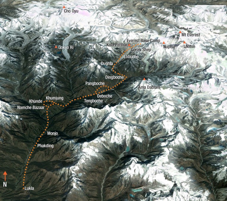
Everest Base Camp Trek reveals some of the most breathtaking scenery in the Himalayas. After exploring Kathmandu, you fly to Lukla where your trek to Everest begins. The trail follows the course of the Dudh Kosi, the ‘River of Milk’, gradually climbing through forests of rhododendron and magnolia. There are rest days at Namche Bazaar (the delightful Sherpa capital) and at Dingboche village (set below the spectacular peak of Ama Dablam) – to help adjust to the altitude.
By the time, you reach Loboche the temperature will have dropped and you will be walking among frozen rivers in an icy wilderness. From here, you make the trek to Base Camp itself – at the foot of the world’s highest peak. The next day brings you to the final highlight – Kalar Patar (5545m) with stunning views of Everest and the Khumbu Glacier cascading below.
Daily from September to late December and February to June
15 Days
Medium-Hard
5545m
Read our helpful check list to make a booking
Tea House
Panoramic view from Syangbuche, experiencing Sherpa culture in Khumjung village and Tengboche Monastery. Views of Mt. Everest from Kala Pattar peak.
Upon arrival at Kathmandu International Airport our staff will greet you and escort you to your hotel in Kathmandu. Depending upon your arrival time you may spend free time visiting nearby cultural sites, shopping or simply resting at the hotel.
Today we will be finalizing your trek preparations and permits. You will have the afternoon to explore the shops and cultural sites of Kathmandu and do any last minute gear shopping. In the afternoon or evening (your preference) you will enjoy a traditional Nepali welcome dinner and a trek briefing with your guide.
Early in the morning you will be picked up by one of the ITrekEverest staff to go to the airport, from where you will take the 35 minute flight to Lukla. The Lukla flights depart from Ramechhap during peak season and Kathmandu during the off-season. You can read more about this here – (Lukla flights) At Lukla we will meet with our porters and head north to Chablung (2700m). Here we will cross the Tharo Kosi river on a local-style suspension bridge. Just past the bridge we can see the peak of Kusum Kangru (6367m), which is the most difficult of the so-called “trekking peaks”. Beyond the Tharo Kosi the trail climbs a bit towards Ghat (2590m), we will cross a ridge marked with painted mani stones and then cross a bridge over the Dudh Kosi river to our overnight lodge in Phakding (3 hrs).
From Phakding we follow the valley of the Dudh Kosi river, staying on the west bank of the river. We climb steeply over a rocky ridge towards Benkar (2710m). From here the trail continues alongside the river. All along this part of the trail, villages are interspersed with magnificent forests of rhododendron, magnolia and giant firs. In both the early autumn and late spring, the flowers on this portion of the trek make it a beautiful walk. We cross the Kyashar Khola river and climb out of the valley to Monjo (2840m). Just beyond Monjo the trek enters the Sagarmatha (Everest) National Park, which was established in 1976 to protect a 1148 sq km area surrounding Mt Everest. Beyond the national park entrance station, the trail makes a steep rocky descent and crosses the Dhud Kosi river on a 120m-long suspension bridge towards Jorsale (2830m). After crossing this river a few times while climbing our way up the valley we will reach Namche Bazaar (3420m). Namche Bazaar is the main trading centre in this region and features numerous shops, hotels and restaurants (6 hrs).
Acclimatisation is important before proceeding higher. Today we will take a day hike through the villages of Khunde and Khumjung. We start with a steep one-hour climb to the Shyangboche airstrip (3790m), from where we will slowly ascend towards Khunde passing numerous chorten (stone Buddhist monuments). From Khunde we follow the trail eastwards to Khumjung, the largest village in Khumbu, at the foot of the sacred peak Khumbila. After enjoying lunch here we will follow a steep switchbacking trail descending to Chhorkung (3540m). From here it is a quick descent back to Namche Bazaar (5 hrs).
Our route of today to Tengboche weaves in and out of side valleys, making small ups and downs, to the teashops of Kenjoma, and joins the trail from Khumjung just before a collection of mani stones. The views of Everest and Ama Dablam are excellent from this part of the trek. We pass the small settlement of Sanasa from where the trail drops towards Phunki Thanga (3250m). From here the trail climbs steeply through forests and around mani stones as it follows the side of a hill to the saddle on which the monestary of Tengboche sits at 3870m. The view from here is rightly deemed to be one of the worlds most magnificent. Kwangde (6187m), Tawachee (6542m), Everest, Nuptse, Lhotse (8501m), Ama Dablan, Kantega and Thamserku provide an inspiring panorama of Himalayan giants. We will spend the night in Tengboche village (5 hrs).
From Tengboche we start our day by descending through forests of birches, conifers and rhododendrons to the village of Devuche. From here the level trail passes many mani walls in a deep rhododendron forest. After crossing the Imja Khola river the route climbs past some magnificently carved mani stones to Pangboche (3860m). This is the highest year-round settlement in the valley, and the Pangboche gompa is the oldest in Khumbu and once contained relics that were said to be the skull and hand of a yeti. Beyond Pangboche the route enters alpine meadows above the tree line, mostly consisting of scrub juniper and tundra. We will cross the Khumbu Khola river and arrive in Pheriche, which is a labyrinth of walls and pastures (4:30 hrs).
The most important thing to acclimatisation to high altitudes is a slow ascent. Therefore it is imperative that we spend an additional night at Pheriche to aid the acclimatisation process. A good way to spend the day is to hike to the small summer settlement of Chhukung at 4730m. From here we have tremendous views of Island Peak (6189m), the south face of Lothse and the south eastern face of Ama Dablam. After enjoying the views here we return back to Pheriche (4 hrs).
The trail of today ascents the broad, gently sloping valley from Pheriche to Phalang Karpo at 4320m. In many places the trail crosses small streams on boulders. Beyond Phalang Karpo the trail climbs steeply onto the terminal moraine of the Khumbu Glacier, then joins the trail from Dingboche and contours down to a stream, crossing it on a bridge just before Duglha (3 hrs).
From Dughla the trail goes directly up the terminal moraine of the Khumbu Glacier for about an hour to the memorial area known as Chukpilhara, which was built in memory of six Sherpas who died in an avalanche during the 1970 Japanese skiing expedition on Everest. From here the trail drops a bit and follows the western side of the valley to Lobuche, a summer settlement at 4930m that has become a major trekking stop. The sunset on Nuptse, seen from here, is a memorable sight.
The first section of todays trail follows the western side of the broad Khumbu valley and ascents gently through meadows besides the glacial moraine. The ascent becomes steeper and rougher as it crosses several side moraines. After rounding a bend in the trail, the conical peak of Pumori comes into view. On the lower slopes of this mountain a ridge extending to the south terminates in a small peak, known as Kala Pattar (5545m), meaning ‘black rock’. The trail then makes a short descent onto the sandy, flat expanse of Gorak Shep. From here we will continue to the current Everest base camp, which is about a 4 hours return walk from Gorak Shep. We will return to this small settlement after our visit to the base camp (6 hrs).
After an early morning rise we will start our day by climbing the Kala Pattar (5545m). This is a steep ascent up the grassy slopes west of Gorak Shep. From Kala Pattar the entire Everest south face is visible as well as Lho La (the pass between Nepal and Tibet, also named the Western Cwm), Changtse (the northern peak of Everest) and most of the West-Ridge route. We return to Gorak Shep and continue to descent to Lobuche (6 hrs).
To go to Dingboche we retrace our steps back to Dughla, and then go straight up the hill from the bridge to reach an upper trail, staying high above the valley floor. The views from here are great. You can easily recognise Island Peak and the top of Makalu is visible in the distance over the pass to the right of Island Peak. After passing a chorten we will descent to Dingboche, where we will stay the night (4 hrs).
The route from Dingboche desents the Imja valley, then crosses the Khumbu Khola on a wooden bridge and climbs to rejoin the upward trail at some stone huts. Following the trail downhill from here we will arrive at Tengboche (3 hrs).
Today we retrace our trail what we followed on day 04 to reach Namche Bazaar (5 hrs).
It is a long walk from Namche Bazaar to Lukla, but we are probably all in good shape by now. From Namche, we will descent steeply back to the Dudh Kosi river and continue our way past the national park checkpoint at Monjo. The trail then continues back towards Lukla, where we will reconfirm our flight tickets for the next day and spend the night (7 hrs).
The 35 minutes flight from Lukla will bring us back to Kathmandu. Overnight stay at hotel.
Departure from Kathmandu or continue onward travels in Nepal.